

Nothing To Do But Stay
June 25, 2019
Features
Audrey Fraizer

Nothing says dedication like working through a disaster hoping everything at home stays the way you left it hours or days earlier.
At least Holli Jordan could count on the pine trees.
“Our house is surrounded by them,” Holli said. “We live in true Florida. Pine trees. Red maples. Oak.”
Holli and Darnell Jordan own a home in southwest Florida, an hour’s driving distance to a Gulf Coast shoreline. Darnell is a retired paramedic, and Holli is an emergency dispatch supervisor at the Lee Control, Lee County Emergency Communications Center, Fort Myers, Florida (USA). She’s worked through conditions most of us only read about (fortunately), including hurricanes and wildfires.
“We got a little wind from Hurricane Michael,” she said. “Hurricane Irma seemed to come through fast, and it hit us directly. I left work not knowing what I’d find once I got home.”
Darnell, on the other hand, had a different impression of the storm’s speed, listening to it approach from where he was hunkered down during the worst of it.
The Atlantic hurricane season officially runs from June 1 through Nov. 30 every year, although storms can and do occur outside of that window (about 3 percent). While extended forecasts must be eyed cautiously, a forecast released in December 2018 predicts the Atlantic’s cyclone activity in 2019 at about 80 percent: 8 to 16 tropical storms, with 2 to 8 that could become hurricanes and up to 4 intense hurricanes of Category 3 strength or greater.1

Lee County in southwest Florida has had its share of natural disasters, and a teeter-totter is the perfect analogy when it comes to comparing the risk associated with a slew of events. The end that is up in the air holds almost no weight considering the low risk threat of tornadoes or earthquakes. When it comes to hurricanes and storm surge, however, the heavy weight keeps the other end down to the ground.
The danger lies in the county’s western edge.
The shallow Gulf of Mexico coastline heavily weights the risk for hurricane threats, specifically storm surges, according to “Hurricane Jim” Bjostad, Manager, Emergency Management Program, Lee County Emergency Management; statistically, Lee County will incur a 1-in-11 risk of a hit in any given hurricane season.2
Hurricanes have hit or brushed the county repeatedly, and Holli has worked through at least 10 named hurricanes: Andrew, Category 5, 1992; Charley, Category 4, 2004; Francis, Category 2, 2004; Ivan, Category 3, 2004; Jeanne, Category 3, 2004; Rita, Category 3, 2005; Wilma, Category 3, 2005; Matthew, Category 2, 2016; Irma, Category 4, 2017; and Michael, Category 4, 2018. As an emergency dispatcher, she answers the 911 calls during the event, but is prohibited from sending response units until winds drop below 40 miles per hour, according to Lee County emergency service policy.
Of course, not all hurricanes make landfall and not all hurricanes carry the same impact.
“Irma was the worst,” said Holli, an emergency dispatcher in Lee County for 28 years. “Unbelievable. My husband was home and said Irma sounded like a freight train coming through.”

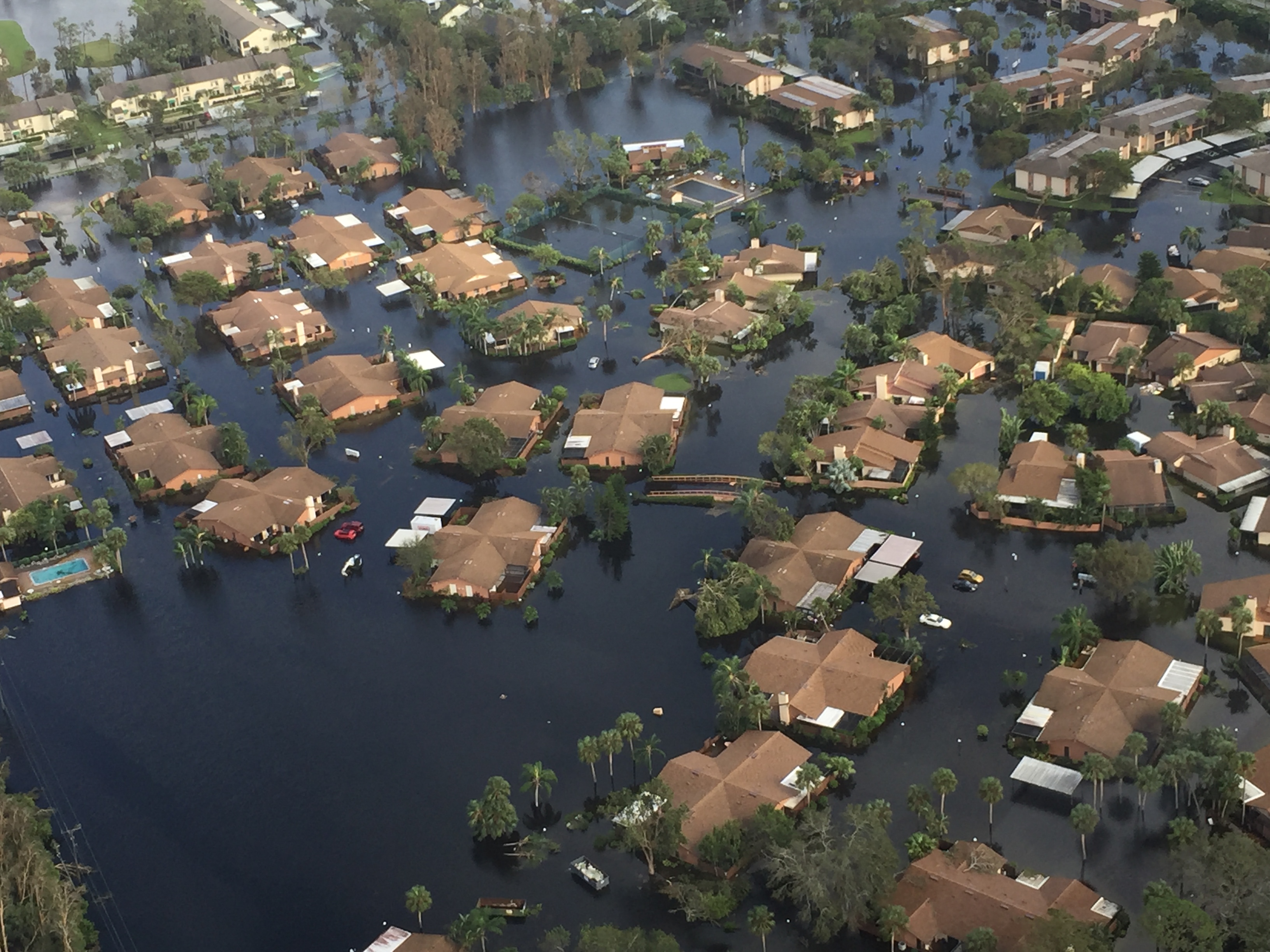
The Jordan family's home is in the county’s interior, away from the coast, where Holli said they felt protected from the brunt of storms and storm surge. Yet, because the inevitable does happen, they keep a portable generator ready for hook-up and have added storm weather precautions throughout the house.
“I never thought we’d lose our home,” she said. “I thought maybe a tree would fall on the roof, but nothing more than that.”
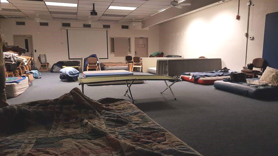
Holli went to the county’s emergency dispatch center 24 hours ahead of the time Irma was expected to make landfall (Sept. 10, 2017, in Lee County). She packed a week’s supply of clothes and a sleeping bag, brought in a clothes rack for everyone to share, and planned to stay at work for at least the next 24 to 48 hours.
“I’ve done this so many times, it’s like second nature,” she said. “It’s part of what we do.”
Holli stayed four days. When winds blew down cell towers, she lost the only connection to home that she had. She drove the familiar roads back not knowing what she would find, although a downed mosquito abatement airplane flipped on its side over a home, snapped concrete phone poles, piles of flood debris, and trees lying in the middle of the road gave her a daunting indication. Some 35,000 Lee County residents and 3,550 of their pets went to 14 shelters, more than any other Florida county.
“I was scared,” she said. “It's so hard when you’re working and can’t get through to family.”
Holli's home was spared. Darnell and the couple’s three dogs were safe, unharmed. Despite plans to leave in their RV before the storm hit, he had stayed home corralled in a closet with the dogs.
“It was such a relief when I saw my husband and the dogs,” she said. “I cried.”
A threatened natural disaster activates every emergency dispatcher, according to Chief Casey M. Allo, Program Manager, Lee Control, Lee County Public Safety. It’s policy. During Irma, the schedule was six hours on, six hours off, with four shifts covering a 24-hour period. Tables turned on their side in the center’s conference room afforded individual privacy during the off hours.
Call volume increased considerably during Hurricane Irma and post-storm, from a normal daily number of 225–250 calls made to 911 to 600–700 calls made to 911. Emergency dispatchers did not deviate from the scripted Medical Priority Dispatch System™ (MPDS®) Protocol. They followed Case Entry and Key Questions and, when indicated, provided Post-Dispatch and Pre-Arrival Instructions.
The scripted “I’m sending the paramedics to help you now” is where instructions deviated. As approved by local policy and the IAED™, dispatchers informed callers that weather conditions prohibited sending response; help would be sent as soon as conditions permitted. Calls were triaged according to patient severity as assessed through the MPDS. The higher the risk, according to priority symptoms, the higher the Determinant Code (with ECHO and DELTA triaged prior to CHARLIE, BRAVO, ALPHA, and OMEGA). Calls were returned when response could go out, with the patient’s condition at that time establishing the priority level in the triage system. If no one at the number provided answered, the level remained the same as at the time of the initial call.
Dispatchers also took administrative calls for heads of departments monitoring the storm in the separate emergency operations center.
Chief Allo said they train for the worst scenarios. They’re prepared: staffing, schedules, frozen food stocked and ready to cook in microwaves on-site, and, as noted, the conference room converted to bunkers. The center is built to withstand hurricane force winds and surge.
The tough part is knowing what the emergency dispatchers are forced to leave behind, said Chief Allo, and it’s no different for him. “I boarded up the house, pulled out of the driveway, and said good-bye,” he said. “I had sent my family away, I knew they were safe, and it was time I went to work.”
Katrina scoured Mississippi’s coastline
Charles Clampett is pragmatic when it comes to mixing business and personal life during extreme weather conditions.
“You come to work and do what is expected,” said Clampett, currently a paramedic and dispatcher for American Medical Response in South Mississippi (USA). “That might sound cold, but I understand. If a storm threatens, you still show up for work.”
Like Holli Jordan, Clampett has the preparation routine down pat. He boards up his house, arranges care for his pets, and hopes for the best when he returns home. The routine was severely tested when Hurricane Katrina reached coastal Mississippi early on Aug. 29, 2005.
Clampett was then a Paramedic Supervisor for Acadian Ambulance and Emergency Operations Center Pre-Hospital liaison covering Jackson county—one of the three coastal counties Katrina just about obliterated off the map. Hurricane Category 3 winds (125 miles per hour) and storm surge destroyed large sections of Hancock, Harrison, and Jackson counties. Surge covered almost the entire lower half of Hancock County, and in Harrison County, up to 10 feet of water channeled in downtown Biloxi with about the same in Jackson county. Ninety percent of Mississippi’s easternmost city, Pascagoula, and 100 percent of the low-lying areas in Jackson County, were flooded from surge.
Clampett established a communication center with a line dedicated to ambulance dispatch inside Pascagoula’s Singing River Hospital. As a paramedic, he had sat in dispatch and understood the way ProQA® worked and set up a telephone triage system.
During the storm, Biloxi Police Department emergency dispatchers answered calls from people who had not evacuated and were pleading for rescue as rising water flooded their neighborhoods and homes. The dispatchers, unable to send response, provided the only advice they could: escape to a place above water (attics, roofs, etc.). The evacuation orders relayed to the public days prior to landfall were every bit as much for the safety of residents as it was for the safety of responders.
“We circulated the number to municipalities,” Clampett said. “If people needed an ambulance, they’d call this number. We had paramedics wading through eight feet of water in Pascagoula.”
WLOX, a Biloxi news station, won a 2005 Peabody Award for the coverage provided by the 50 employees who stayed at the station the night before Katrina made landfall, the day of, and the 12 days immediately following. Reporters roamed the area donning high boots and hooded trench coats, pointing out Gulf waves crashing into a usually placid coastline, interviewing people who chose not to evacuate, standing under the eaves of their building to show audiences accelerating wind speed and rain fall, and—after it was over—charting the devastation. The coverage was sobering, heart-breaking, and historic.
The damage was inconceivable, Clampett said.
“People remember New Orleans because the levees broke and the water flooded and stayed,” he said. “The water came in and the water went out at the Gulf Coast, but it scoured the surface. It was horrible. People were in shock, milling around in a daze after the storm had passed. It was sweltering, humid and hot. People didn’t know where to go, what they would do.”
Essential to the extreme
Cold weather requires extra layers to stay warm. Cold temperatures plunging below historic lows means you don’t venture out unless, of course, you’re an emergency dispatcher.
Dispatchers are termed essential employees under Waukesha County’s (Wisconsin, USA) emergency conditions policy, meaning that due to the nature of their jobs, they are required to report to work during declared emergency conditions.
Even if that wasn’t county policy, they’d most likely come in, said Waukesha County Communication Center Training and Operations Manager Sherri Stigler.
“Dispatchers know what to expect when they get into this,” Stigler said. “They don’t take their responsibilities lightly.”
The Polar Vortex invading the Midwest during late January shot temperatures to double digits below zero (Fahrenheit) and—adding bone deep cold to frigid air—blasted winds putting people in extreme danger when venturing out in a wind chill of minus 35 to minus 50 degrees in Waukesha, a county in the state’s southeast corner. A day before the cold set in, nine inches of snow fell.
Waukesha County office buildings were closed on Monday due to the anticipated snowfall with likely dangerous driving conditions. Waukesha County courthouse and county offices were closed on the coldest days—Wednesday, Jan. 30, and Thursday, Jan. 31. Schools and businesses were closed. No mail was delivered.
The 12 dispatchers that were normally at work during the day shift were increased by one in anticipation of call volume and, sure enough, that’s what happened but not to the extreme you might expect. Icy, snow-blown roads affected local and highway travel. From midnight to 6 p.m. on Monday, Jan. 28, Waukesha County Sheriff’s Deputies responded to 60 property damage accidents, 14 personal injury accidents, 85 cars in ditches, and 81 disabled vehicles. The 911 calls related to frigid temperatures included frostbite and a house fire possibly related to the use of alternative heating fuel.
The center also hosted 27 emergency medical dispatchers in a three-day certification course taught, ironically, by Barbara Ireland, former Deputy Chief of Communications for New Orleans Emergency Medical Services (NOEMS). Katrina flooded both E911 call centers and all E911 switching equipment. No E911 or regular telephone service was available. She spent five months living out of a suitcase in a small room and on a ship temporarily housing EMS. Each morning they’d report to work.
“We’re not in that same position from the cold,” Stigler said. “We can send. Like every place else, it’s a matter of being prepared and doing the best we can considering the conditions.”
Planning for the worst
Barry Furey is a public safety consultant and trainer and former director of Raleigh-Wake Communication Center in North Carolina (USA), a state ranked fifth for homes at risk for natural disasters.3
“Murphy was an optimist,” said Furey referring to Murphy’s Law. “Everything will go wrong that can go wrong, but [for emergency services] it will be at the most inappropriate time.”
Nine of Furey’s 45 years in public service was dedicated to Raleigh-Wake (January 2006–December 2014), during which time he directed emergency communications through hurricanes, tropical storms, flooding, winter storms, and tornadoes. His recommendations for natural disaster planning are based on experience managing four 911 communication centers in four states. While written policies and procedures are vital to any operation, he also advocates erring on the side of initiative, common sense, and the willingness to set aside standard operating procedures (SOP).
“There are times you can ignore the SOP,” he said. “What happens when the unthinkable hits at 3 a.m. on a Sunday and the manual doesn’t take the unthinkable into account? You’re lost. You have nothing to go on. I recommend using the manual as general guidance, but you can't expect people to follow a procedure manual written like it’s for an assembly line.”
Furey can list multiple situations when initiative and preparation in the spirit of Murphy’s Law ruled the day. The issues and their potential varied: natural disasters, technology, power outages, and populations exposed to hazardous manmade elements. He preferred, when able, to use reality-based training similar to other public services.
“It’s easier for a firefighter to raise a 40-foot ladder in a book than in the middle of the night in pouring rain,” he said. “Communications needs more of that.”
His first in on-the-job training at Raleigh-Wake put emergency dispatchers in an off-site backup unit built to accommodate communications in case central operations went down. Problem was, it had never been rigorously exercised. “The capacity was actually diminished,” Furey said. “Neither the people or the equipment had been adequately tested. No one likes surprises in communications. Dispatchers have enough to worry about with the next call coming in.”
Furey ran operations from the backup for several days, rotating emergency dispatchers and supervisors through to “exorcise all ghosts from the machines” and create the feeling of second nature when conditions forced a shift in operations. He repeated the training exercise annually for new and seasoned staff.
“You can make any plan you want on paper, but you will never adequately plan unless you practice,” he said.
Furey related an experience from a previous center, when a sudden crash of the CAD system forced familiarity with the MPDS cardset that evolved into standard practice. The “old-timers” didn’t stress without the CAD. They never skipped a beat, automatically pulling out the cards, pens, and paper. The newcomers who had never trained on these procedures “walked around like deer in the headlights,” he said. “That’s when two things hit me,” he added. “First, basic training needs to include both normal and emergency operations. And, secondly, continuity of operations is actually a long-term goal that is heavily dependent upon short-term actions. You have got to successfully transcend that critical minute when the crisis hits in order to be up and running two days later.”
Reporting for duty at the communication center during a natural disaster is second nature. It’s ingrained as part of the job’s responsibilities, Furey said. People arrive early “just in case” and, if they are unable to drive, municipal vehicles provide pick up and drop off.
“You never want to place your people in physical jeopardy or expose them to any type of danger,” Furey said. “Yet, it’s been my experience, that people come in when not called [voluntarily] rather than refusing to come when called.”
A checklist applies here: accommodations, either at the center or nearby hotel/motel, food, rotations, and a consistent message for callers threatened by conditions jeopardizing field response. Emergency personnel learn the ropes of preparation, such as arrangements for family and pets, and securing their homes, when necessary.
“There is a certain amount of dedication that comes with the territory, and dispatchers accept that responsibility,” Furey said. “This is not your typical 9 to 5 job. There are expectations. As much as people don’t like to think about bad things happening, it's all part of emergency services along with knowing what to do when they do happen.”
Sources
1Saunders M, Lea A. “Extended Range Forecast for Atlantic Hurricane Activity in 2019.” Tropical Storm Risk.com. 2018; Dec. 11. http://www.tropicalstormrisk.com/docs/TSRATLForecastDec2019.pdf (accessed Jan. 28, 2019).
2“Prep Now for Hurricane Season.” Island Sand Paper. 2018; May 31. https://fortmyersbeach.news/prep-now-for-hurricane-season/ (accessed Jan. 28, 2019).
3Hoyle A. “N.C. ranks No. 5 for homes at risk of natural disaster, report shows.” Triangle Business Journal. 2015; Sept. 8. https://www.bizjournals.com/triangle/blog/real-estate/2015/09/n-c-ranks-no-4-for-homes-at-risk-of-natural.html (accessed Jan. 30, 2019).
More Articles


